![](/images/other/stat-length.png)
![Excursión A pie Gemeinde Mauerbach - Hainbuch - Steinriegl - Photo](https://media.geolcdn.com/t/1900/400/68851d89-591e-4d81-99d3-d7b7db706624.jpeg&format=pjpeg&maxdim=2)
Hainbuch - Steinriegl
SityTrail - itinéraires balisés pédestres
Tous les sentiers balisés d’Europe GUIDE+
![Longitud](/images/other/stat-length.png)
![Altitud máxima](https://static1.geolcdn.com/siteimages/upload/files/1508320355ic_sort_altitude_max_24dp.png)
![Desnivel positivo](https://static1.geolcdn.com/siteimages/upload/files/1508320355ic_sort_den_pos_24dp.png)
![Km-Effort](/images/other/stat-length.png)
![Altitud mínima](https://static1.geolcdn.com/siteimages/upload/files/1508320355ic_sort_altitude_min_24dp.png)
![Desnivel negativo](https://static1.geolcdn.com/siteimages/upload/files/1508320355ic_sort_den_neg_24dp.png)
![Boucle](https://static1.geolcdn.com/siteimages/upload/files/16400158638029165_repeat_loop_refresh_sync_direction_icon.png)
![A pie](https://static1.geolcdn.com/sitytour/trail-icons/100.png)
1h14
Dificultad : Fácil
![Escanee este código QR para abrir la excursión en la aplicación SityTrail](https://capi.geolives.com/qq0zvz2zws4bq2lad0pu/sitytour/trails/3127490/qr.png?size=200)
Aplicación GPS de excursión GRATIS
A propósito
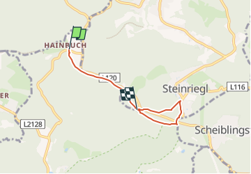
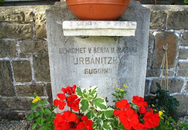
Ruta A pie de 3,9 km a descubrir en Baja Austria, Bezirk St. Pölten, Gemeinde Mauerbach. Esta ruta ha sido propuesta por SityTrail - itinéraires balisés pédestres.
Descripción
Trail created by ÖTK-Klosterneuburg.
Symbol: weiss-gelb-weiss
Sitio web: https://www.oetk-klosterneuburg.at/index.php/unsere-wege/weginformation/392-hainbuch-steinriegl
Localización
Comentarios
Excursiones cerca
![Excursión A pie Gemeinde Mauerbach - 2 - Photo](https://media.geolcdn.com/t/375/260/8a232dc7-7727-41c9-a60d-eecf8d080c78.jpeg&format=jpg&maxdim=2)
![A pie A pie](https://static1.geolcdn.com/sitytour/trail-icons/100.png)
A pie
![](/images/other/stat-length.png)
![](https://static1.geolcdn.com/siteimages/upload/files/16400158638029165_repeat_loop_refresh_sync_direction_icon.png)
![Excursión A pie Gemeinde Tulbing - 4 - Photo](https://media.geolcdn.com/t/375/260/0d73597f-b6c5-48cb-b90a-c6acfa01772c.jpeg&format=jpg&maxdim=2)
![A pie A pie](https://static1.geolcdn.com/sitytour/trail-icons/100.png)
A pie
![](/images/other/stat-length.png)
![](https://static1.geolcdn.com/siteimages/upload/files/16400158638029165_repeat_loop_refresh_sync_direction_icon.png)
![Excursión A pie Gemeinde Mauerbach - Königstetten - Hainbuch - Photo](https://media.geolcdn.com/t/375/260/68851d89-591e-4d81-99d3-d7b7db706624.jpeg&format=jpg&maxdim=2)
![A pie A pie](https://static1.geolcdn.com/sitytour/trail-icons/100.png)
A pie
![](/images/other/stat-length.png)
![](https://static1.geolcdn.com/siteimages/upload/files/16400158638029165_repeat_loop_refresh_sync_direction_icon.png)
![Excursión A pie Gemeinde Gablitz - 3 - Photo](https://media.geolcdn.com/t/375/260/39661cbf-63bd-42c5-8e2b-998fe2b80a90.jpeg&format=jpg&maxdim=2)
![A pie A pie](https://static1.geolcdn.com/sitytour/trail-icons/100.png)
A pie
![](/images/other/stat-length.png)
![](https://static1.geolcdn.com/siteimages/upload/files/16400158638029165_repeat_loop_refresh_sync_direction_icon.png)
![Excursión A pie Gemeinde Tulbing - 1 - Photo](https://media.geolcdn.com/t/375/260/65ed6883-459c-42e4-b5b6-d983bc223f05.jpeg&format=jpg&maxdim=2)
![A pie A pie](https://static1.geolcdn.com/sitytour/trail-icons/100.png)
A pie
![](/images/other/stat-length.png)
![](https://static1.geolcdn.com/siteimages/upload/files/16400158638029165_repeat_loop_refresh_sync_direction_icon.png)
![Excursión A pie Desconocido - Sophienalpe - Scheiblingstein - Photo](https://media.geolcdn.com/t/375/260/d4c9f0e8-6c63-4664-8a2a-a66dd875a234.jpeg&format=jpg&maxdim=2)
![A pie A pie](https://static1.geolcdn.com/sitytour/trail-icons/100.png)
A pie
![](/images/other/stat-length.png)
![](https://static1.geolcdn.com/siteimages/upload/files/16400158638029165_repeat_loop_refresh_sync_direction_icon.png)
![Excursión A pie Gemeinde Mauerbach - Mauerbach - Steinriegl - Photo](https://media.geolcdn.com/t/375/260/c5609fc2-43e7-45d9-bc2a-207e2e2acfd9.jpeg&format=jpg&maxdim=2)
![A pie A pie](https://static1.geolcdn.com/sitytour/trail-icons/100.png)
A pie
![](/images/other/stat-length.png)
![](https://static1.geolcdn.com/siteimages/upload/files/16400158638029165_repeat_loop_refresh_sync_direction_icon.png)
![Excursión A pie Desconocido - Hütteldorf/Endstation Linie 49 - Sophienalpe - Photo](https://media.geolcdn.com/t/375/260/253a6813-08fa-4a81-a70e-4b57f01b5ec7.jpeg&format=jpg&maxdim=2)
![A pie A pie](https://static1.geolcdn.com/sitytour/trail-icons/100.png)
A pie
![](/images/other/stat-length.png)
![](https://static1.geolcdn.com/siteimages/upload/files/16400158638029165_repeat_loop_refresh_sync_direction_icon.png)
![Excursión A pie Gemeinde St. Andrä-Wördern - Hadersfeld über Schneiderzipf - Photo](https://media.geolcdn.com/t/375/260/8b832b6b-68e5-4fac-a71f-bc2c59562d59.jpeg&format=jpg&maxdim=2)
![A pie A pie](https://static1.geolcdn.com/sitytour/trail-icons/100.png)
A pie
![](/images/other/stat-length.png)
![](https://static1.geolcdn.com/siteimages/upload/files/16400158638029165_repeat_loop_refresh_sync_direction_icon.png)